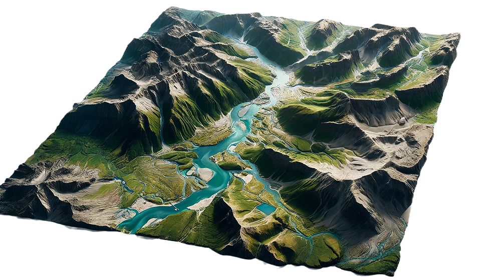
Aerial Mapping
At Dronespect, we provide top-tier aerial mapping services across Australia, specializing in projects for both the government and private sectors. Our expertise spans various applications, including land management, urban development, agriculture, and environmental monitoring. With our unmatched experience, we deliver highly accurate topographic maps with centimeter-level precision, ensuring that our clients receive the detailed information they need for effective decision-making.
Why Choose Dronespect for Aerial Mapping?
Precision and Accuracy: Utilizing the latest in drone technology, we produce topographic maps with centimeter-level accuracy. This precision is crucial for projects that require detailed and reliable data.
Advanced Drone Technology: Our fleet of advanced drones is equipped with high-resolution cameras, allowing us to capture comprehensive aerial data efficiently.
Expert Pilots: Our team of experienced and certified pilots ensures that every aerial mapping project is conducted safely and effectively, adhering to all regulatory standards.
Rapid Turnaround: We understand the importance of timely data. Our streamlined processes enable us to deliver fast and reliable results, helping you make informed decisions promptly.
Versatile Applications: From land management and urban planning to agriculture and environmental monitoring, our aerial mapping services are tailored to meet the specific needs of various industries.
.png)
Tell Us About Your Project
Please send us an inquiry including the basic details about your project's requirements, location, and expected completion date. We will get back to you soon.
Key Benefits of Our Aerial Mapping Services
-
Enhanced Decision-Making: Accurate and detailed maps provide critical insights, enabling better planning and resource management.
-
Cost-Effective Solutions: Aerial mapping with drones is more efficient and cost-effective compared to traditional surveying methods.
-
Comprehensive Coverage: Our drones can cover large and inaccessible areas quickly, providing a comprehensive overview of the terrain.
-
Customizable Data Outputs: We offer various data formats and outputs, tailored to suit your specific project requirements.
Industries We Serve
-
Government Projects: Urban planning, infrastructure development, disaster management, and more.
-
Private Sector: Real estate development, agriculture, mining, and environmental monitoring.

Deliverables we provide
Dronespect can deliver a wide range of file types to suit your needs, ensuring that all necessary data is accessible in the format most convenient for your operations. Our services are tailored to meet your specific requirements, providing you with comprehensive and precise information for thorough analysis and documentation. Our goal is to ensure that you have all the necessary information in the most efficient and effective format to facilitate your inspection and maintenance processes

Orthomosaic maps are high-res, georeferenced maps created from aerial images for precise surveying.
Orthomosaic Maps
3D textured maps are detailed 3D models with realistic surface textures created from drone imagery.
3D Textured Maps
%20created%20from%20drone%20imagery%2C%20s.webp)
Digital Elevation Models (DEMs) are 3D representations of terrain elevations derived from drone data.
Digital Elevation Model (DEM)

Contours are lines on maps indicating equal elevation, used for representing terrain relief.
Contours


Mapping Services for Badge Constructions
We are proud to have partnered with Badge Constructions on their Queensland Government School development project, providing comprehensive mapping services to ensure the success and safety of their initiative. Our team conducted monthly mapping sessions to deliver critical insights and updates throughout the construction process.
Monthly Mapping Schedule
To maintain the highest standards of health and safety and to keep the project on track, our mapping services were performed on a monthly schedule. This regularity allowed us to:
Identify Health and Safety Areas: By mapping the construction site monthly, we could pinpoint potential health and safety hazards, ensuring that Badge Constructions could address these issues promptly to maintain a safe working environment.
Monitor Progress: Regular mapping allowed us to track the development's progress accurately. This helped Badge Constructions stay on schedule and make informed decisions about resource allocation and project timelines.
Provide Development Updates: Our detailed maps offered a clear visual representation of the site's ongoing development. These updates were crucial for project stakeholders to understand the current state of construction and plan future activities accordingly.
Our commitment to precision and reliability in mapping services ensures that projects like the Queensland Government School development by Badge Constructions can proceed efficiently and safely. By providing actionable insights and regular updates, we help our partners achieve their construction goals while maintaining high standards of safety and quality.